Image collection »Sextener Tal«
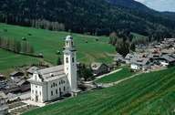
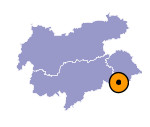
A low, forested slope divides the entrance of the Sextener Tal from the flat bottom of the Pustertal and Innichen. Like the valleys of Prags and Antholz this southern tributary valley of the Pustertal has its entrance in the main valley. On the sunny slopes of the valley forests reach up to an altitude of around 2000 m. Sexten was first mentioned in a document in 965 when the valley was given to the Benedictines in the monastery in Innichen. Due to the mild climate the sunny slope in the upper part of the valley were settled during the Schwaighof settlements. During World War I the front ran near Sexten. That was why large parts of the village and the parish church were destroyed by shell fire in 1915.

|
|
Further links: Weblink »Wikipedia«
